

Summer well and truly has us in its grip, with hot temperatures in store and the risk of severe weather dipping into western Kentucky this week.
Lead Forecaster Keith Cooley with the National Weather Service in Paducah says there’s a lot going on in the atmosphere this week, with Canadian wildfire smoke, a building heat dome and the threat of severe weather in the forecast. That severe risk will mainly take place during the afternoon hours Tuesday for central and western Kentucky, with the main threat damaging wind gusts, with our tornado risk very low.
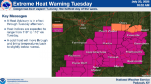
The bulk of the area is in a Slight Risk outlook. That storm front will bring some welcome relief from the heat with it though, as there’s a Heat Advisory in place Monday and then an Excessive Heat Warning in place for Tuesday.
Cooley says heat index values could touch 115 degrees Tuesday before the cold front races through with the storms.
We’ll get a short break in the heat during the mid-week, before it starts building back up again in time for the weekend. And folks could see a haze on the horizon as well, as the storm front will pull smoke from wildfires in Canada right down into the western Kentucky region.
Areas to our northeast are more likely to get the big impacts from that smoke. In the 8-to-14-day outlook, it looks like we might get a chance to dry out some with no big calls for rain in the forecast, but temperatures are looking to trend well above average, continuing out streak of hot weather.
Stay tuned to the WHOP Family of Stations for any watches or warnings that may develop.