

The Winter Storm Warning is set to continue through Wednesday morning across all of western Kentucky, with everyone likely to see at least some snow—and it could really impact travel conditions.
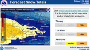
Meteorologist Dan Spaeth with the National Weather Service in Paducah says they are predicting that at a minimum, most people will likely see at least three inches of snow, but higher amounts of six inches or more are possible across the area from Tuesday night into Wednesday.
The snow will likely be a pretty dry snow—which on one hand is a little easier to drive on, but on the other hand, can result in blowing and driving snow that brings its own driving hazards.
Temperatures will be downright frigid during the event and then be dangerously cold immediately after, with some places reaching the single-digits—and that will be even colder when you factor in windchill. Spaeth encouraged everyone to prepare for that cold as best as you can.
Temperatures won’t moderate back to above freezing until Saturday or Sunday, so whatever snow does fall will stick with us until then.