

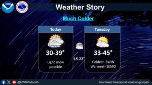
The storms and the wind have brought winter back to the region, but don’t worry, as spring is going to fight back with rebounding warm temperatures later in the week.
This week is starting cold and maybe even snowy in some places, but Forecaster Rachel Trevino with the National Weather Service in Paducah says those conditions won’t stick around for long. In fact, we could bounce back all the way back into the 80’s by the end of the week.
There could be some snow in the area Tuesday night and into Wednesday morning, but Trevino says nothing about it looks very impressive, so they’re not expecting much in the way of accumulation.
There’s also little no signs of precipitation in the forecast this week either, and in the 8-to-14-day outlook, Trevino says that dryness looks to continue, with temperatures trending above normal.
Temperatures will plunge well below freezing Monday and Tuesday night, so make sure to bring that sensitive vegetation inside or give it some cover, or else risk losing it to the bite of winter.
Stay tuned to the WHOP Family of Stations for any advisories that may come about with our brief return to winter.