

It’s going to feel a lot like summer this week, with off-and-on rain chances, warming temperatures and some thunderstorms possible.
In a conference call Monday, Lead Forecaster Sean Poulos with the National Weather Service in Paducah says the week will start dry, with some of the hottest temperatures of the year so far, but then daily rain chances return on Wednesday.
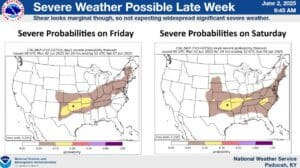
Some places across the region could see between 2-to-4 inches of rain throughout the week and into the weekend, with lower amounts possible in western Kentucky. Poulus says Saturday and Sunday could have a chance of severe storms, but right now it looks to be fairly low-end—though that will be determined.
Speaking of severe weather, there have been a lot of warnings issued by the Paducah office in 2025—in fact, Poulos says there’s been 452 severe weather-related warnings so far.
The office will also be conducting a required update to the Advanced Weather Interactive Processing System—which is used to send information and warnings out to the public, starting on June 9. The update will likely take a couple of days, and during that time, operations will be conducted by the service back-up offices.