

After gusty winds and a powerful cold front brought severe storms to the region Sunday night, the weather for the rest of the week looks to chill out—literally.
Those storms brought plunging temperatures to us following an extended time of above average temperatures, and they caused some havoc along with way, putting a lot of folks in the dark with widespread power outages. Some areas along the Kentucky-Indiana border event saw a tornado or two, with Meteorologist Justin Gibbs with the National Weather Service in Paducah calling this a tricky weather event to forecast for.
He says they’ll work to evaluate damage and see if they can accurately determine if it was caused by straight line winds or a spin-up tornado.
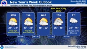
With that behind us, Gibbs says we can expect cold temperatures to start out our week, before the level out to a more seasonal temperature, with not much expected in the way of precipitation.
Looking even further ahead into the 8-to-14-day outlook, Gibbs says the data is trending slightly warmer and with near normal precipitation, and he doesn’t really see any severe weather possibilities on the horizon.
It was a very busy year for weather in 2025, and the National Weather Service will continue to forecast and prepare us for whatever weather lies in store for the year ahead.