

After the remnants of a potent storm system move out of the area Monday, the National Weather Service in Paducah says the rest of the work week is looking much calmer.
While the western Kentucky area dodged the bullet on weather Sunday, areas to our north in Illinois and Indiana were not so lucky, as a tornado outbreak brought destruction, injuries and fatalities to the mid-west. Meteorologist Andy Lesage says damage survey teams will be in Illinois for likely the rest of the day and into tomorrow, as they try to determine how strong and how many tornadoes touched down in their service area Sunday night.
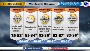
That number could reach the double-digits, with some storms spawning multiple tornadoes on their own. Now, rain and some blustery storm chances will linger through the rest of the week, though no one day will be a complete wash out, with Lesage calling it a fairly typical summer pattern.
Sunday was the summer solstice, and Lesage says our temperatures might start to climb up this week, with some days in the upper 90’s possible next week.
In the 8-to-14 day outlook, temperatures are trending slightly above normal with fairly average chances for precipitation. Stay tuned to the WHOP Family of Stations for any watches or warnings that may pop-up in the heat of our summer days.