

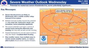
Severe weather is looking increasingly likely for the region—including western Kentucky—tonight and especially Wednesday, with all hazards possible.
Meteorologist Justin Gibbs with the National Weather Service in Paducah says they’re more confident in storms turning severe this afternoon, and they’ll bring with them a risk for tornadoes, damaging winds and large hail, especially in any super-cells that develop.
The area is under a slight-risk for severe weather this afternoon and evening, but that changes to an enhanced risk on Wednesday, with Gibbs saying discreet severe storms are certainly possible before a line of storms races through in the evening, with conditions favorable for damaging winds and potentially strong tornadoes.
Storms that develop ahead of the line would carry the biggest threat, with Gibbs saying stay weather aware tomorrow, as storms could start developing as early as mid-morning.
Gibbs says it’s possible that not everyone sees storms on Wednesday, but since it’s nigh impossible to know exactly where a storm will form ahead of time, everyone needs to be alert.
Stay tuned to the WHOP Family of Stations for more on this developing weather system, and for any watches or warnings that may be issued.