

A storm system that has already spawned tornadoes, hail and severe weather of all types as it makes it’s way across the country, it’s set to enter our region on Monday, bringing more severe weather.
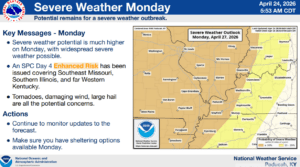
The Storm Prediction Center has already highlighted the bulk of the area for an Enhanced Risk of severe weather on Monday afternoon and evening, even though we’re still several days out from the event. Christian, Todd and Trigg counties are currently highlighted in a Slight Risk of severe weather, but that could be upgraded in the coming days.
Meteorologist Derrick Snyder with the National Weather Service in Paducah says they are growing increasingly concerned about the potential for possibly significant severe weather on Monday, as it seems that all the ingredients you need for all hazards are present.
Snyder urges everyone to stay weather aware this weekend, and take the time to prepare for severe weather now—get that sheltering space ready to go, go over severe weather plans and get everything you’d need together in one place.
Over the weekend, Snyder says they will be able to develop a timeline map for the storm system, but right now, it looks like the system could arrive in the region around 3 p.m. to 4 p.m. on Monday.
With this event still approaching, it’s likely some details will change as more data and information comes in, so stayed tuned to the National Weather Service in Paducah and the WHOP Family of Stations for additional information.