

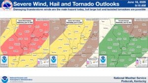
There remains a risk for severe storms this afternoon and evening—in fact, portions of Christian, Todd and Trigg counties have been upgraded to an Enhanced Risk for severe weather.
The southern portions of those counties remain under a Slight Risk, but either way, the main hazard is going to be damaging winds. Warning Coordinator Meteorologist Christine Wielgos says there will also be a chance for large hail, and while the tornado risk is very low, a brief, spin-up tornado can’t be ruled out.
The timing on when severe weather could develop is trickier to pin down—Wielgos says storms could start firing in the early afternoon, but could happen as late as the early evening hours, and they’re not expecting an all-out outbreak of severe weather.
After today’s storms move out, the temperature is set to ratchet up, with heat index values touching the lower 100’s for the first time this year—but the good news is, the rain looks to hold off for the start of the Western Kentucky State Fair.