

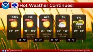
Summer is not going out without a fight, as temperatures will be down right scorching this week before a cold front brings some relief, along with a chance for rain, this weekend.
Forecaster Rachael Trevino with the National Weather Service in Paducah says real air temperatures could possibly touch 100 degrees in some places, so you can imagine how it will feel when combined with the humidity—but relief is on the way, when a cold front slides through the region Friday evening.
However, the chances for thunderstorms and rain are not terribly high, and anything that does develop will likely be scattered, meaning not everyone will see rain.
Trevino says that’s not great for the drought status, which she expects to be upgraded to ‘abnormally dry’ for the bulk of the region later this week. But then in the 8-to-14-day outlook, there could be some increased chances for rain, and they are showing some cooler temperatures to usher in September.
Stay tuned to the WHOP Family of Stations for any updates to this developing weather system, as summer fights back against a slowly encroaching autumn.