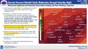
Meteorologists with the National Weather Service in Paducah are very concerned about the flooding event that will follow Wednesday’s severe storms.
It’s looking likely that most of the area could see major flooding, with parts of western Kentucky under the gun to possibly receive 10 to 15 inches of rainfall between Wednesday and Saturday. Meteorologist Justin Gibbs with the National Weather Service in Paducah says some places could even receive historic flooding if everything comes together, but if the storm front manages to move enough out of our area, we could have brief breaks in the rainfall, which would help.
The severe risks continue during that time frame as well, though not at the level it was Wednesday. However, Gibbs says the severity will resurge on Saturday, with all hazards once again on the table.
Have multiple ways to receive warnings and be ready to act immediately if a warning is issued for your area. This week will remain very active for weather, from rain to storms, so try and stay as weather aware as possible.
Stay tuned to the WHOP Family of Stations for any watches or warnings that may develop.


