

We’ll get a small break from the hot temperatures in the mid-week, but other than that, it’s looking like the heatwave is here to stay for a while longer.
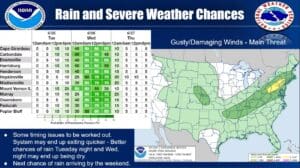
Christine Wielgos is the Warning Coordination Meteorologist with the National Weather Service in Paducah and says most of the region will be in the upper 90’s at times over the coming week, with areas to our west under a Heat Advisory—so be careful if you have spend time outdoors. Then, some rain and storms will roll through Tuesday into Wednesday, cooling things down some.
There is a marginal chance for severe weather during those storms, with damaging winds the primary threat.
The cool off won’t last for long, with the heat ramping back up towards the end of the week, and then the above average temperatures continue in the 8-to-14-day outlook.
It’s possible the Heat Advisory could make it’s way further east, so stay tuned to the WHOP Family of Stations for any updates that develop with this heatwave.