

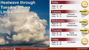
It’s going to feel like more of the same weather-wise this week, with hot temperatures to start things out and then things will cool down in the mid-week.
There is currently a Heat Advisory in effect for the entire region, including Christian, Todd and Trigg counties, with heat index values in the peak of the day of 108 degrees possible. But don’t worry, this isn’t expected to be an extended heatwave like the last one. Meteorologist Justin Gibbs with the National Weather Service in Paducah says a cold front will start pushing through Tuesday night that will help bring the temperatures down some.
He says there does exist some chance for thunderstorms in the region’s western counties, but most folks in western Kentucky may only see some rain. After that, it’s his hope this will be the last of the heat advisories for the year.
In the 8-to-14-day outlook, it’s looking we’re in for average temperatures and maybe above average chances for precipitation—which Gibbs says wouldn’t be too bad, considering some areas are actually starting to get abnormally dry.
Stay tuned to the WHOP Family of Stations for any watches, warnings or advisories that might arise in the coming week.