

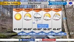
It looks like this week is signaling a return to wintry temperatures, and you may even see a few snowflakes in the air in the latter half of it.
While the start of the week will have fairly mild temperatures, a cold front bringing rain Tuesday night into Wednesday will cool things right back down. Lead Forecaster Keith Cooley with the National Weather Service in Paducah says that’s when our first chance for some snow fall will occur—but it’s not looking all that impressive.
There will be another chance for snow in the air on Friday into Saturday, but once again, Cooley says it’s looking like there won’t be much accumulation to speak of.
In the 8-to-14-day outlook, Cooley says things are looking pretty average, with near normal temperatures and near normal chances of precipitation, though they are keeping an eye on a signal for possible active weather.
Nothing is set in stone, so stay tuned to the WHOP Family of Stations and the National Weather Service in Paducah for any watches or advisories that may come about from this winter system.