

After an extended heatwave followed by pop-up thunderstorms that brought burst of heavy rain—it looks like the weather might just calm down for western Kentucky.
But first, we need to get through a Marginal Risk for thunderstorms, some of which could be strong on Monday and into Tuesday morning. Meteorologist Justin Gibbs with the National Weather Service in Paducah says the parameters aren’t all that impressive however, and there’s a good chance we get into Tuesday with no severe warnings being issued.
The chance for storms is fueled by a cold front that will work its way through the region, and as it goes, it should clear the way for some dryer weather with seasonable temperatures just in time for the Fourth of July—which means it will be hot, but not unbearably so.
Gibbs says it’s looking like a return to normal summer weather in the 8-to-14-day outlook, meaning hot temperatures and the chance for an occasional thunderstorm during the heat of the day.
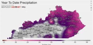
Gibbs did share an interesting bit of data in how much rainfall has been had in Kentucky so far in 2025 and western Kentucky is the winner of that unwanted contest. Christian County has had 44 inches of rain so far in 2025, according to the Kentucky Mesonet, while Todd County has had near 40 inches and Trigg County saw just over 45 inches of rain.
Marshall County takes home with grand prize however, with 50.6 inches of rain.