

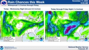
It’s looking like the region could be in store for a period of unsettled weather, starting Monday night into Tuesday, as storms move into the area.
Those storms will bring plenty of rain with them, especially Tuesday afternoon and into the evening. Lead Forecaster Keith Cooley with the National Weather Service in Paducah says that’s not our only hazards though, as those storms could also bring the risk of small hail and brief, spin-up tornadoes.
The tornado risk is a low-end one, but can’t be completely ruled out. After that—it’s more rain in the forecast, all the way into Friday, and temperatures will be chilly.
In the 8-to-14-day outlook, Cooley says the trends are setting us up for a stormier weather pattern, with warmer than average temperatures possible, but also above average chances for precipitation.
Then, in the long-range outlook, forecasters are keeping an eye on a possible active weather pattern for Thanksgiving and into the following weekend, but it’s still too far out to have solid details on any risk that might present.
So, stay tuned to the WHOP Family of Stations for any watches or warnings that may arise during our week of stormier weather.