

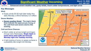
Go ahead and tie that porch furniture down as you batten down the hatches, because all of western Kentucky is under an Enhanced Risk for severe weather Sunday evening into the overnight hours.
That includes Christian, Todd and Trigg Counties, as a line of storms is set to howl through the area Sunday night in front of a cold front, and it will bring the chance for widespread damaging winds and a couple of tornadoes. Meteorologist Justin Gibbs with the National Weather Service in Paducah says there will be enough spin in the atmosphere that a tornado is certainly possible, and it would have the risk of being a strong one as well, even if it spins up on the squall line.
The biggest, and most likely, hazard will be damaging winds, with Gibbs saying winds of over 75 miles per hour will be possible, with even higher speeds possible in areas. That would knock down trees and power lines—he says the probabilities of that happening are high enough that we should be preparing now.
Winds will be fairly gusty even outside of any storms that develop as it rushes in that cold front. Gibbs says you’ll feel the cold front alright, as temperatures will plummet down into the single-digits Monday morning. There could be some snow chasing our severe weather, though they’re not expecting much in the way of accumulation, but Gibbs says motorists should be cautious for slick spots on area roadways.
Warnings are likely tonight, so make sure you have multiple ways to receive warnings, especially those that will wake you up if you’re sleeping, and stay tuned to the WHOP Family of Stations to stay up-to-date on weather information.