

The week will start out cold before temperatures warm up, bringing with them a good chance for rain in the latter half of it.
Monday and Tuesday will be our coldest days of the week, so says Lead Forecaster Keith Cooley with the National Weather Service in Paducah, and then the week will warm to more seasonal temperatures, bringing rain chances on Thursday.
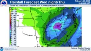
That rain would be a beneficial one, says Cooley, as there’s actually an elevated fire risk for the region, including western Kentucky, as gusty winds and dry conditions could make a stray spark catch quickly.
In the 8-to-14-day outlook, it’s looking temperatures could trend higher than normal, with above average chances for precipitation. Cooley says if we can dodge any severe weather, then the precipitation would be a good thing.
Speaking of severe weather, there’s nothing concrete in the forecast at this time, but Cooley says they are keeping an eye on a period of possibly active weather during the first week of March. Stay tuned to the WHOP Family of Stations and the National Weather Service in Paducah for any watches or warnings that may pop up.