

We have a bit of an active weather pattern in store for the week, but worry not, because Thanksgiving Day itself looks to be cool and dry.
In fact, Meteorologist Derrick Snyder with the National Weather Service in Paducah says they’re hopeful it will be dry Wednesday, Thursday and Friday, which would be great for Thanksgiving travelers. Snyder says the week starts out rainy and gloomy, dries out for the holiday and then rain chances return Saturday and into next week.
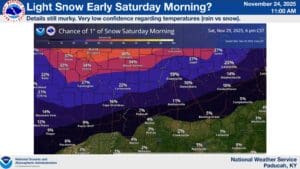
The word snow is even possible for Saturday morning as a cold front bullies its way into the region, mostly focused on areas to our north, but Snyder says a lot of details remain up in the air—it will all come down to where the coldest air and moisture meet.
Right now, there’s no severe weather in the forecast, but Snyder says this time of year can be sneaky where it comes to storms, made evident by a surprise tornado that struck parts of Todd County early Saturday morning.
With warmer than average temperatures in trending in the 8-to-14-day outlook, along with above average chances of precipitation, then our relationship with active and possibly stormy weather is likely not over just yet. Stay tuned to the WHOP Family of Stations for any watches, warnings, or even snow that may develop.