

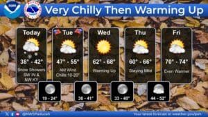
With snow in the air and icy temperatures, western Kentucky got a reminder that winter is on its way—but don’t worry, cold-haters, because it won’t stick around.
Temperatures will struggle to get out of 30’s Monday and Tuesday, but after that, Meteorologist Justin Gibbs with the National Weather Service in Paducah says it’s expected to warm right back up to near 70 by the later half of the week.
While some areas did see some snow flakes Monday morning, nothing accumulated beyond a slight dusting on elevated surfaces, and that was only in isolated areas. Gibbs says it’ll be sunny through the rest of the week, before the weekend brings our next chances for rain and thunderstorms.
In the 8-to-14 day outlook, it’s looking like warmer than average temperatures are in store, along with above average chances for precipitation. Gibbs says we’re entering the time of the year where above average temperatures starts to worry them, as it normally brings with it an increased chance for severe weather—but for now, they’re not seeing anything too concerning in the data.
Stay tuned to the WHOP Family of Stations, and the National Weather Service in Paducah, for any watches or warnings that could develop as we continue through our Fall Severe Weather season.