

The seasonably hot temperatures are here to stay and the chances for stormy weather return this week.
Lead Forecaster Justin Gibbs with the National Weather Service in Paducah calls the current weather cycle a broken record and says average temperatures are set to remain in the high 80s. Through Thursday, Gibbs says the region is stuck in a weak high-altitude wind pattern coming from the Gulf of Mexico that could spark storms.
Each day of the week comes with a chance for stormy weather, but those chances are low. For Monday afternoon and evening, parts of Christian, Todd and Trigg counties are under a marginal risk for severe weather. At most, Gibbs says there could be some isolated hail and high wind and the tornado risk is extremely low.
Gibbs says rain chances are higher on Tuesday and Wednesday, and then a cold front may impact the region toward the weekend, but he’s skeptical about that.
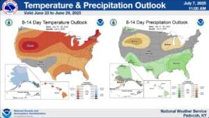
In the 8-to-14-day outlook, Gibbs says temperature and precipitation levels are expected to be slightly above normal. He expects heat index values to be in the 100s and due to the humid weather pattern drought risks are low.
However, toward the end of July Gibbs says there is a chance that drought conditions might settle into the region.