

While we’re off to a very fall-like start this week, that won’t last for long, as temperatures are set to climb back up and then the remnants of Tropical Storm Francine splash into the region.
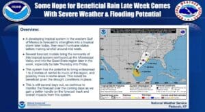
Francine will make landfall in Louisiana from the Gulf of Mexico, and it is expected to reach hurricane status before that happens in the mid-week. Lead Forecaster Dan Spaeth with the National Weather Service in Paducah says where exactly that track then goes once it is in-land isn’t entirely certain, but it will impact the region in some way, whether that be heavy rainfall or severe storms.
It will enter the region likely sometime Thursday night, and while areas to the east of the track could get severe weather, it most likely is looking like a big rain maker.
Spaeth says that rain is sorely needed, as the bulk of western Kentucky is now in ‘moderate drought’ status, and a good soaking rain would help alleviate those conditions, though it could result in some minor flooding issues.
There’s still plenty of details to be ironed out concerning Tropical Storm Francine, so stayed tuned to the National Weather Service in Paducah and the WHOP Family of Stations for more on this developing weather system.