

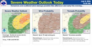
The remnants of Tropical Storm Beryl are causing mischief in our part of the world today, with tornadoes certainly on the table with any storms that develop.
Meteorologist Derrick Snyder with the National Weather Service in Kentucky held a conference call Tuesday morning and says the atmosphere is primed with moisture and instability, and with Beryl bringing in the wind, it’ll be just right for storms. Those storms could bring hazards of damaging winds and heavy rainfall, but Snyder says they’re most concerned with the tornado potential.
He says it’s most likely that any tornadoes that materialize will be a brief spin-up tornado, but if a discrete storm can get into the right atmosphere, he can’t rule out a longer lasting tornado.
Heavy rain will remain possible through the night, but the highest risk for severe storms for our area will be between 3 p.m. and 7 p.m. After that, the rest of the week looks calm and dry.
Stayed tuned to the WHOP Family of Stations for any watches or warnings that develop with this system as what remains of Tropical Storm Beryl races to the northeast.