
Hopefully you’ve been enjoying our recent string of summer weather, because it’s looking like more of the same this week, with pop-up storms possible and hot temperatures certain.
That’s according to Meteorologist Rachel Trevino with the National Weather Service in Paducah, who says that while the rain chances are not incredibly high on any given day, you can never really rule out a pop-up thunderstorm in the heat of a summer day.
She says that while storm coverage would be widely scattered, any storms that did develop would be prolific rainmakers.
Outside of the possibility of rain and storms, Trevino was much more confident in the temperature forecast. She says temperatures will linger in the mid-to-upper 90’s for most of the week, with head index values touching 100 degrees at times.
Trevino says that’s about what you would expect for mid-July and they’ll keep an eye out for if they’ll need to issue any heat advisories.
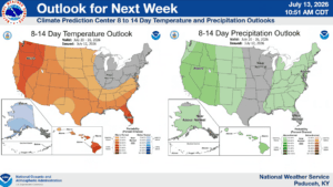
In the 8-to-14-day outlook, things are looking very average in data, with temperatures hovering at just about dead average, and only slightly above average chances for precipitation.